


Roche la Croix

janussity
User
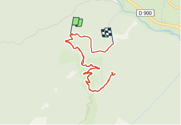

Length
5.4 km

Max alt
2100 m

Uphill gradient
213 m
Km-Effort
8.3 km

Min alt
1880 m

Downhill gradient
221 m
Boucle
No
Creation date :
2023-08-25 08:37:28.464
Updated on :
2023-08-25 12:12:45.115
1h54
Difficulty : Medium

FREE GPS app for hiking
 SityTrail
IGN / Geographical institutes
SityTrail Plus
The world is yours!
About
Trail Walking of 5.4 km to be discovered at Provence-Alpes-Côte d'Azur, Alpes-de-Haute-Provence, Val-d'Oronaye. This trail is proposed by janussity.
Description
Visite du fort de Roche la croix
Photos

Positioning
Country:
France
Region :
Provence-Alpes-Côte d'Azur
Department/Province :
Alpes-de-Haute-Provence
Municipality :
Val-d'Oronaye
Location:
Meyronnes
Start:(Dec)
Start:(UTM)
324421 ; 4926393 (32T) N.
Comments