


les croix de Sevrier

vienne14400
User
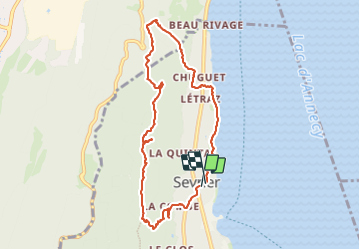

Length
8.6 km

Max alt
802 m

Uphill gradient
418 m
Km-Effort
14.1 km

Min alt
448 m

Downhill gradient
415 m
Boucle
Yes
Creation date :
2023-08-25 12:07:14.201
Updated on :
2023-08-25 14:58:58.751
2h51
Difficulty : Difficult

FREE GPS app for hiking
 SityTrail
IGN / Geographical institutes
SityTrail Plus
The world is yours!
About
Trail Walking of 8.6 km to be discovered at Auvergne-Rhône-Alpes, Upper Savoy, Sevrier. This trail is proposed by vienne14400.
Positioning
Country:
France
Region :
Auvergne-Rhône-Alpes
Department/Province :
Upper Savoy
Municipality :
Sevrier
Location:
Unknown
Start:(Dec)
Start:(UTM)
278103 ; 5082875 (32T) N.
Comments