


Andenne 290823

guyernage25
User
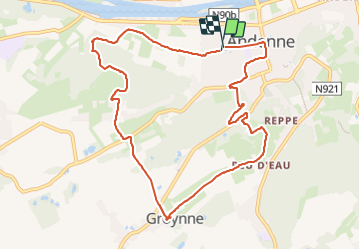

Length
9.9 km

Max alt
226 m

Uphill gradient
236 m
Km-Effort
13 km

Min alt
73 m

Downhill gradient
237 m
Boucle
Yes
Creation date :
2023-08-29 08:46:16.745
Updated on :
2023-08-29 12:14:10.551
3h27
Difficulty : Medium

FREE GPS app for hiking
 SityTrail
IGN / Geographical institutes
SityTrail Plus
The world is yours!
About
Trail Walking of 9.9 km to be discovered at Wallonia, Namur, Andenne. This trail is proposed by guyernage25.
Description
belle balade dans les collines boisées d Andenne
Attention au km 7,5 forte pente
Photos


Positioning
Country:
Belgium
Region :
Wallonia
Department/Province :
Namur
Municipality :
Andenne
Location:
Unknown
Start:(Dec)
Start:(UTM)
648240 ; 5595008 (31U) N.
Comments