


track

CANON2
User
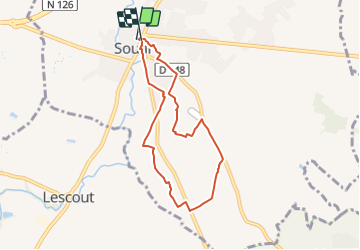

Length
7.1 km

Max alt
203 m

Uphill gradient
54 m
Km-Effort
7.8 km

Min alt
167 m

Downhill gradient
53 m
Boucle
Yes
Creation date :
2023-08-30 05:09:21.69
Updated on :
2023-08-30 05:10:56.519
1h46
Difficulty : Easy

FREE GPS app for hiking
 SityTrail
IGN / Geographical institutes
SityTrail Plus
The world is yours!
About
Trail On foot of 7.1 km to be discovered at Occitania, Tarn, Soual. This trail is proposed by CANON2.
Positioning
Country:
France
Region :
Occitania
Department/Province :
Tarn
Municipality :
Soual
Location:
Unknown
Start:(Dec)
Start:(UTM)
428563 ; 4822894 (31T) N.
Comments