


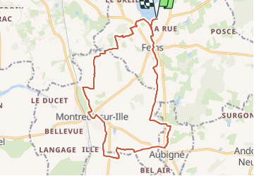
17,8km. JY. Etang de Boulet, Montreuil/Ille, Aubigné, Feins, étang

COGLAIS3
User

Length
17.8 km

Max alt
103 m

Uphill gradient
168 m
Km-Effort
20 km

Min alt
55 m

Downhill gradient
168 m
Boucle
Yes
Creation date :
2023-08-30 08:21:19.243
Updated on :
2023-09-06 14:53:04.405
3h54
Difficulty : Easy

FREE GPS app for hiking
 SityTrail
IGN / Geographical institutes
SityTrail Plus
The world is yours!
About
Trail Nordic walking of 17.8 km to be discovered at Brittany, Ille-et-Vilaine, Feins. This trail is proposed by COGLAIS3.
Positioning
Country:
France
Region :
Brittany
Department/Province :
Ille-et-Vilaine
Municipality :
Feins
Location:
Unknown
Start:(Dec)
Start:(UTM)
600839 ; 5354830 (30U) N.
Comments