


fees

brandy
User
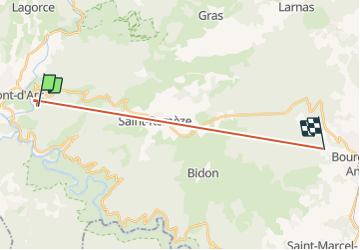

Length
16.8 km

Max alt
417 m

Uphill gradient
594 m
Km-Effort
25 km

Min alt
119 m

Downhill gradient
601 m
Boucle
No
Creation date :
2023-08-31 16:05:33.858
Updated on :
2023-08-31 19:28:02.798
14m
Difficulty : Very difficult

FREE GPS app for hiking
 SityTrail
IGN / Geographical institutes
SityTrail Plus
The world is yours!
About
Trail Walking of 16.8 km to be discovered at Auvergne-Rhône-Alpes, Ardèche, Vallon-Pont-d'Arc. This trail is proposed by brandy.
Description
gr
Positioning
Country:
France
Region :
Auvergne-Rhône-Alpes
Department/Province :
Ardèche
Municipality :
Vallon-Pont-d'Arc
Location:
Unknown
Start:(Dec)
Start:(UTM)
613163 ; 4917185 (31T) N.
Comments