


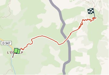
Viso-J1 l'Echalp - Col de la Croix - Rifugio Willy Jerviz

MAD-CVW
User


2h51
Difficulty : Difficult

FREE GPS app for hiking
 SityTrail
IGN / Geographical institutes
SityTrail Plus
The world is yours!
About
Trail Walking of 7.8 km to be discovered at Provence-Alpes-Côte d'Azur, Hautes-Alpes, Abriès-Ristolas. This trail is proposed by MAD-CVW.
Description
Départ à lEchalp, à droite de l'église par le GRP> Belle montée progressive par forêt de mélèzes et doux sentiers en lacets. traversé de chaumes toujours en montant vers le col de la Croix a 2299m. Passage frontière entre les grands blocs rocheux pour descendre les lacets. Cheminement entre les petits arbres pour arriver au refugio Gerviz. Super refuge.
Positioning
Comments