


20230903

ludol
User

Length
44 km

Max alt
541 m

Uphill gradient
783 m
Km-Effort
55 km

Min alt
208 m

Downhill gradient
782 m
Boucle
Yes
Creation date :
2023-09-03 06:07:05.308
Updated on :
2023-09-03 09:09:10.437
2h57
Difficulty : Very difficult

FREE GPS app for hiking
 SityTrail
IGN / Geographical institutes
SityTrail Plus
The world is yours!
About
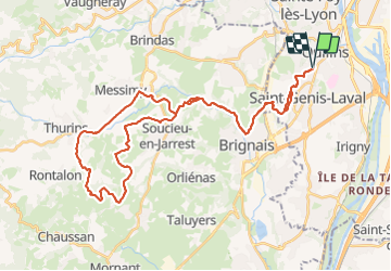
Trail Mountain bike of 44 km to be discovered at Auvergne-Rhône-Alpes, Métropole de Lyon, Saint-Genis-Laval. This trail is proposed by ludol.
Positioning
Country:
France
Region :
Auvergne-Rhône-Alpes
Department/Province :
Métropole de Lyon
Municipality :
Saint-Genis-Laval
Location:
Unknown
Start:(Dec)
Start:(UTM)
639799 ; 5063160 (31T) N.
Comments