


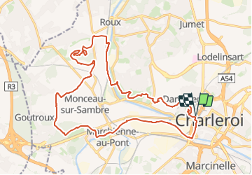
Boucle Noire Charleroi

Nicolas Van Meerbeck
User

Length
21 km

Max alt
199 m

Uphill gradient
364 m
Km-Effort
26 km

Min alt
96 m

Downhill gradient
363 m
Boucle
Yes
Creation date :
2023-09-03 06:05:37.505
Updated on :
2023-09-03 10:45:34.113
4h39
Difficulty : Easy

FREE GPS app for hiking
 SityTrail
IGN / Geographical institutes
SityTrail Plus
The world is yours!
About
Trail Walking of 21 km to be discovered at Wallonia, Hainaut, Charleroi. This trail is proposed by Nicolas Van Meerbeck.
Positioning
Country:
Belgium
Region :
Wallonia
Department/Province :
Hainaut
Municipality :
Charleroi
Location:
Unknown
Start:(Dec)
Start:(UTM)
602106 ; 5585579 (31U) N.
Comments