


bellecombe st open doucy villages 40 planes charrette combelouvier douce bellecombe

franquen
User
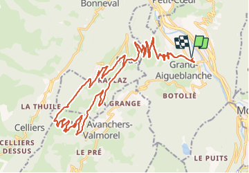

Length
33 km

Max alt
1519 m

Uphill gradient
1135 m
Km-Effort
48 km

Min alt
454 m

Downhill gradient
1135 m
Boucle
Yes
Creation date :
2023-09-03 09:00:45.547
Updated on :
2023-09-03 12:01:20.058
3h00
Difficulty : Very difficult

FREE GPS app for hiking
 SityTrail
IGN / Geographical institutes
SityTrail Plus
The world is yours!
About
Trail Mountain bike of 33 km to be discovered at Auvergne-Rhône-Alpes, Savoy, Grand-Aigueblanche. This trail is proposed by franquen.
Positioning
Country:
France
Region :
Auvergne-Rhône-Alpes
Department/Province :
Savoy
Municipality :
Grand-Aigueblanche
Location:
Aigueblanche
Start:(Dec)
Start:(UTM)
304800 ; 5041886 (32T) N.
Comments