


la hotte aux loups nances

pierrounet
User
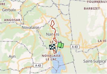

Length
11.2 km

Max alt
616 m

Uphill gradient
283 m
Km-Effort
15 km

Min alt
376 m

Downhill gradient
285 m
Boucle
Yes
Creation date :
2023-09-04 11:19:32.535
Updated on :
2023-09-04 15:00:06.265
3h40
Difficulty : Difficult

FREE GPS app for hiking
 SityTrail
IGN / Geographical institutes
SityTrail Plus
The world is yours!
About
Trail Walking of 11.2 km to be discovered at Auvergne-Rhône-Alpes, Savoy, Nances. This trail is proposed by pierrounet.
Positioning
Country:
France
Region :
Auvergne-Rhône-Alpes
Department/Province :
Savoy
Municipality :
Nances
Location:
Unknown
Start:(Dec)
Start:(UTM)
718529 ; 5050670 (31T) N.
Comments