


Yerres

michelberrier
User
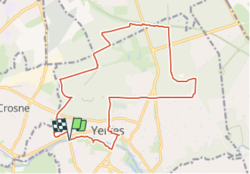

Length
10.1 km

Max alt
118 m

Uphill gradient
133 m
Km-Effort
11.9 km

Min alt
37 m

Downhill gradient
133 m
Boucle
Yes
Creation date :
2023-09-04 17:28:37.524
Updated on :
2023-09-04 17:29:04.572
2h42
Difficulty : Easy

FREE GPS app for hiking
 SityTrail
IGN / Geographical institutes
SityTrail Plus
The world is yours!
About
Trail On foot of 10.1 km to be discovered at Ile-de-France, Essonne, Yerres. This trail is proposed by michelberrier.
Positioning
Country:
France
Region :
Ile-de-France
Department/Province :
Essonne
Municipality :
Yerres
Location:
Unknown
Start:(Dec)
Start:(UTM)
461653 ; 5395928 (31U) N.
Comments