


Pointe du milieu

lorenzot54
User

Length
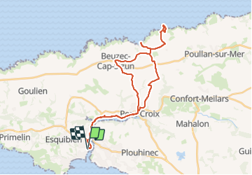
36 km

Max alt
93 m

Uphill gradient
459 m
Km-Effort
42 km

Min alt
0 m

Downhill gradient
458 m
Boucle
Yes
Creation date :
2023-09-06 06:56:35.0
Updated on :
2023-09-06 12:34:10.756

FREE GPS app for hiking
 SityTrail
IGN / Geographical institutes
SityTrail Plus
The world is yours!
About
Trail of 36 km to be discovered at Brittany, Finistère, Audierne. This trail is proposed by lorenzot54.
Positioning
Country:
France
Region :
Brittany
Department/Province :
Finistère
Municipality :
Audierne
Location:
Audierne
Start:(Dec)
Start:(UTM)
385253 ; 5319404 (30U) N.
Comments