


2023-09-06_17h16m11_exp_31 août 2023 à 20-32-17

panetJeanLuc
User
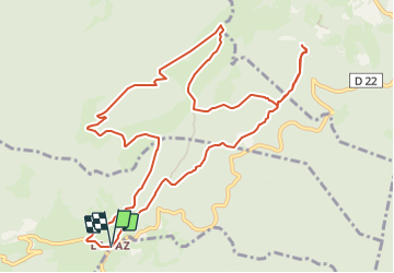

Length
13 km

Max alt
1304 m

Uphill gradient
494 m
Km-Effort
19.6 km

Min alt
955 m

Downhill gradient
493 m
Boucle
Yes
Creation date :
2023-09-06 15:16:11.123
Updated on :
2023-09-06 15:16:14.267

FREE GPS app for hiking
 SityTrail
IGN / Geographical institutes
SityTrail Plus
The world is yours!
About
Trail of 13 km to be discovered at Auvergne-Rhône-Alpes, Isère, Saint-Pierre-de-Chérennes. This trail is proposed by panetJeanLuc.
Description
grp_trc:[visibles]
Positioning
Country:
France
Region :
Auvergne-Rhône-Alpes
Department/Province :
Isère
Municipality :
Saint-Pierre-de-Chérennes
Location:
Unknown
Start:(Dec)
Start:(UTM)
688789 ; 4998620 (31T) N.
Comments