


le Viso

Guy Laurent
User
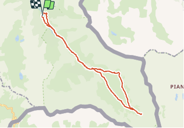

Length
18.8 km

Max alt
2517 m

Uphill gradient
768 m
Km-Effort
29 km

Min alt
1802 m

Downhill gradient
796 m
Boucle
Yes
Creation date :
2023-09-07 07:29:45.217
Updated on :
2023-09-07 19:35:31.646
8h23
Difficulty : Very difficult

FREE GPS app for hiking
 SityTrail
IGN / Geographical institutes
SityTrail Plus
The world is yours!
About
Trail Walking of 18.8 km to be discovered at Provence-Alpes-Côte d'Azur, Hautes-Alpes, Abriès-Ristolas. This trail is proposed by Guy Laurent.
Positioning
Country:
France
Region :
Provence-Alpes-Côte d'Azur
Department/Province :
Hautes-Alpes
Municipality :
Abriès-Ristolas
Location:
Ristolas
Start:(Dec)
Start:(UTM)
341467 ; 4955394 (32T) N.
Comments