


grolay nichecoucou 9,2km

coglais
User

Length
9.2 km

Max alt
188 m

Uphill gradient
173 m
Km-Effort
11.5 km

Min alt
111 m

Downhill gradient
174 m
Boucle
Yes
Creation date :
2015-10-03 00:00:00.0
Updated on :
2019-06-13 15:05:00.664
2h00
Difficulty : Medium

FREE GPS app for hiking
 SityTrail
IGN / Geographical institutes
SityTrail Plus
The world is yours!
About
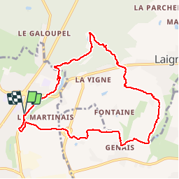
Trail Nordic walking of 9.2 km to be discovered at Brittany, Ille-et-Vilaine, Fougères. This trail is proposed by coglais.
Description
départ centre social de Fougères par GR 34 puis direction La croix aux morts, rte de laignelet, et forêt avec retour par le GR
Positioning
Country:
France
Region :
Brittany
Department/Province :
Ille-et-Vilaine
Municipality :
Fougères
Location:
Unknown
Start:(Dec)
Start:(UTM)
634433 ; 5358188 (30U) N.
Comments