


De Pipay au cret du boeuf

morganee
User
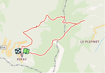

Length
10.1 km

Max alt
1925 m

Uphill gradient
506 m
Km-Effort
16.9 km

Min alt
1496 m

Downhill gradient
509 m
Boucle
Yes
Creation date :
2023-09-09 16:46:49.388
Updated on :
2023-09-09 16:46:50.671
3h49
Difficulty : Easy

FREE GPS app for hiking
 SityTrail
IGN / Geographical institutes
SityTrail Plus
The world is yours!
About
Trail Walking of 10.1 km to be discovered at Auvergne-Rhône-Alpes, Isère, Theys. This trail is proposed by morganee.
Positioning
Country:
France
Region :
Auvergne-Rhône-Alpes
Department/Province :
Isère
Municipality :
Theys
Location:
Unknown
Start:(Dec)
Start:(UTM)
265896 ; 5016807 (32T) N.
Comments