


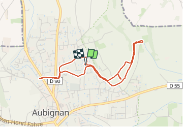
Aubignan canal

MAD-CVW
User

Length
4.6 km

Max alt
97 m

Uphill gradient
38 m
Km-Effort
5.1 km

Min alt
83 m

Downhill gradient
39 m
Boucle
Yes
Creation date :
2023-09-10 09:16:59.774
Updated on :
2023-09-10 10:30:26.659
1h02
Difficulty : Easy

FREE GPS app for hiking
 SityTrail
IGN / Geographical institutes
SityTrail Plus
The world is yours!
About
Trail Walking of 4.6 km to be discovered at Provence-Alpes-Côte d'Azur, Vaucluse, Aubignan. This trail is proposed by MAD-CVW.
Positioning
Country:
France
Region :
Provence-Alpes-Côte d'Azur
Department/Province :
Vaucluse
Municipality :
Aubignan
Location:
Unknown
Start:(Dec)
Start:(UTM)
662480 ; 4885533 (31T) N.
Comments