


Preny

PhilippeC54
User
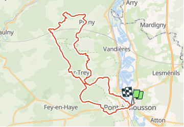

Length
40 km

Max alt
385 m

Uphill gradient
882 m
Km-Effort
52 km

Min alt
177 m

Downhill gradient
877 m
Boucle
No
Creation date :
2023-09-10 06:30:10.448
Updated on :
2023-09-10 11:33:52.445
2h51
Difficulty : Difficult

FREE GPS app for hiking
 SityTrail
IGN / Geographical institutes
SityTrail Plus
The world is yours!
About
Trail Mountain bike of 40 km to be discovered at Grand Est, Meurthe-et-Moselle, Pont-à-Mousson. This trail is proposed by PhilippeC54.
Positioning
Country:
France
Region :
Grand Est
Department/Province :
Meurthe-et-Moselle
Municipality :
Pont-à-Mousson
Location:
Unknown
Start:(Dec)
Start:(UTM)
284282 ; 5420957 (32U) N.
Comments