


Cime du Diable depuis l'Authion

aris
User
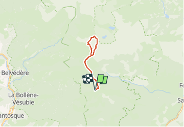

Length
16.7 km

Max alt
2668 m

Uphill gradient
1187 m
Km-Effort
33 km

Min alt
1827 m

Downhill gradient
1186 m
Boucle
Yes
Creation date :
2023-09-10 07:08:03.743
Updated on :
2023-09-11 10:26:54.075
7h12
Difficulty : Medium

FREE GPS app for hiking
 SityTrail
IGN / Geographical institutes
SityTrail Plus
The world is yours!
About
Trail Walking of 16.7 km to be discovered at Provence-Alpes-Côte d'Azur, Maritime Alps, Breil-sur-Roya. This trail is proposed by aris.
Positioning
Country:
France
Region :
Provence-Alpes-Côte d'Azur
Department/Province :
Maritime Alps
Municipality :
Breil-sur-Roya
Location:
Unknown
Start:(Dec)
Start:(UTM)
373971 ; 4872846 (32T) N.
Comments