


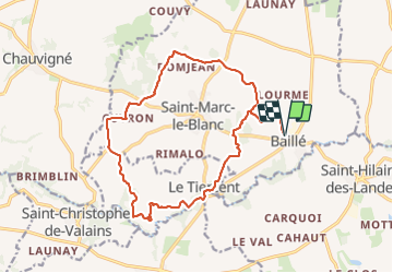
BAILLE-SAINT MARC LE BLANC-LE TIERCENT- BAILLE-17KM-JY

COGLAIS3
User

Length
17.3 km

Max alt
118 m

Uphill gradient
208 m
Km-Effort
20 km

Min alt
59 m

Downhill gradient
209 m
Boucle
Yes
Creation date :
2023-09-11 19:44:18.855
Updated on :
2023-09-11 19:44:18.855
2h54
Difficulty : Easy

FREE GPS app for hiking
 SityTrail
IGN / Geographical institutes
SityTrail Plus
The world is yours!
About
Trail Nordic walking of 17.3 km to be discovered at Brittany, Ille-et-Vilaine, Saint-Marc-le-Blanc. This trail is proposed by COGLAIS3.
Positioning
Country:
France
Region :
Brittany
Department/Province :
Ille-et-Vilaine
Municipality :
Saint-Marc-le-Blanc
Location:
Unknown
Start:(Dec)
Start:(UTM)
619893 ; 5357642 (30U) N.
Comments