


GRP La Vaquerie

werth
User

Length
20 km

Max alt
639 m

Uphill gradient
634 m
Km-Effort
28 km

Min alt
264 m

Downhill gradient
354 m
Boucle
No
Creation date :
2023-09-01 06:31:31.336
Updated on :
2023-09-12 19:29:01.822
8h43
Difficulty : Difficult

FREE GPS app for hiking
 SityTrail
IGN / Geographical institutes
SityTrail Plus
The world is yours!
About
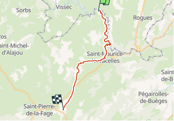
Trail Walking of 20 km to be discovered at Occitania, Hérault, Saint-Maurice-Navacelles. This trail is proposed by werth.
Photos


Positioning
Country:
France
Region :
Occitania
Department/Province :
Hérault
Municipality :
Saint-Maurice-Navacelles
Location:
Unknown
Start:(Dec)
Start:(UTM)
540894 ; 4860304 (31T) N.
Comments