


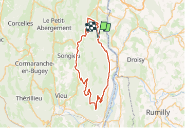
Le Grand Colombier par Anglefort

PhilippeC54
User

Length
61 km

Max alt
1499 m

Uphill gradient
1788 m
Km-Effort
85 km

Min alt
286 m

Downhill gradient
1790 m
Boucle
Yes
Creation date :
2023-09-14 07:02:21.633
Updated on :
2023-09-14 11:02:02.942
3h38
Difficulty : Difficult

FREE GPS app for hiking
 SityTrail
IGN / Geographical institutes
SityTrail Plus
The world is yours!
About
Trail Road bike of 61 km to be discovered at Auvergne-Rhône-Alpes, Ain, Chanay. This trail is proposed by PhilippeC54.
Description
retour par col de Richemond
Positioning
Country:
France
Region :
Auvergne-Rhône-Alpes
Department/Province :
Ain
Municipality :
Chanay
Location:
Unknown
Start:(Dec)
Start:(UTM)
715450 ; 5098367 (31T) N.
Comments