


Circuit cul du sac Mandres la cote

janussity
User
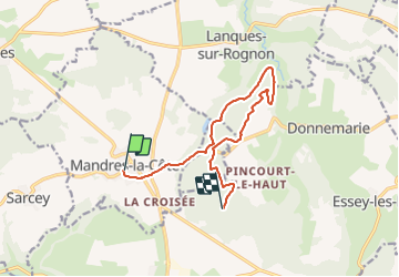

Length
10.7 km

Max alt
438 m

Uphill gradient
121 m
Km-Effort
12.2 km

Min alt
379 m

Downhill gradient
85 m
Boucle
No
Creation date :
2023-09-15 08:17:12.033
Updated on :
2023-09-15 09:37:02.21
1h08
Difficulty : Medium

FREE GPS app for hiking
 SityTrail
IGN / Geographical institutes
SityTrail Plus
The world is yours!
About
Trail Walking of 10.7 km to be discovered at Grand Est, Haute-Marne, Mandres-la-Côte. This trail is proposed by janussity.
Positioning
Country:
France
Region :
Grand Est
Department/Province :
Haute-Marne
Municipality :
Mandres-la-Côte
Location:
Unknown
Start:(Dec)
Start:(UTM)
673954 ; 5325751 (31U) N.
Comments