


Saugues Aumont Aubrac

Nono55
User
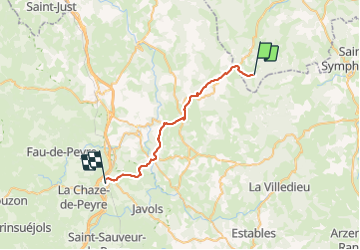

Length
30 km

Max alt
1333 m

Uphill gradient
529 m
Km-Effort
38 km

Min alt
919 m

Downhill gradient
771 m
Boucle
No
Creation date :
2023-09-14 10:55:45.0
Updated on :
2023-09-15 11:57:12.821
7h46
Difficulty : Easy

FREE GPS app for hiking
 SityTrail
IGN / Geographical institutes
SityTrail Plus
The world is yours!
About
Trail Walking of 30 km to be discovered at Auvergne-Rhône-Alpes, Haute-Loire, Chanaleilles. This trail is proposed by Nono55.
Description
Très beau chemin sauf arrivé à St Alban beaucoup de route pour trouver le camping pas top
Parti St Alban a Aumont est magnifique
Positioning
Country:
France
Region :
Auvergne-Rhône-Alpes
Department/Province :
Haute-Loire
Municipality :
Chanaleilles
Location:
Unknown
Start:(Dec)
Start:(UTM)
538533 ; 4963549 (31T) N.
Comments