


notre dame de jérusalem /les sacs/la Louve FREJUS

Michel DUBOIS
User
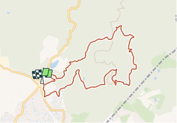

Length
11.4 km

Max alt
253 m

Uphill gradient
376 m
Km-Effort
16.4 km

Min alt
71 m

Downhill gradient
379 m
Boucle
Yes
Creation date :
2023-09-15 14:50:12.273
Updated on :
2023-09-15 14:52:26.847
3h43
Difficulty : Medium

FREE GPS app for hiking
 SityTrail
IGN / Geographical institutes
SityTrail Plus
The world is yours!
About
Trail Walking of 11.4 km to be discovered at Provence-Alpes-Côte d'Azur, Var, Fréjus. This trail is proposed by Michel DUBOIS.
Positioning
Country:
France
Region :
Provence-Alpes-Côte d'Azur
Department/Province :
Var
Municipality :
Fréjus
Location:
Unknown
Start:(Dec)
Start:(UTM)
319318 ; 4815287 (32T) N.
Comments
super rando