


Arpavon-Segillat 17km

thonyc
User GUIDE
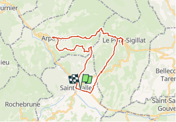

Length
17.2 km

Max alt
801 m

Uphill gradient
600 m
Km-Effort
25 km

Min alt
406 m

Downhill gradient
598 m
Boucle
Yes
Creation date :
2023-09-15 15:43:06.898
Updated on :
2024-05-20 07:27:11.356
5h43
Difficulty : Very difficult

FREE GPS app for hiking
 SityTrail
IGN / Geographical institutes
SityTrail Plus
The world is yours!
About
Trail Walking of 17.2 km to be discovered at Auvergne-Rhône-Alpes, Drôme, Sainte-Jalle. This trail is proposed by thonyc.
Positioning
Country:
France
Region :
Auvergne-Rhône-Alpes
Department/Province :
Drôme
Municipality :
Sainte-Jalle
Location:
Unknown
Start:(Dec)
Start:(UTM)
682257 ; 4912627 (31T) N.
Comments