


thiemesnil

marco14
User
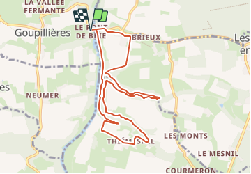

Length
9.1 km

Max alt
97 m

Uphill gradient
168 m
Km-Effort
11.3 km

Min alt
18 m

Downhill gradient
168 m
Boucle
Yes
Creation date :
2023-09-16 13:36:45.23
Updated on :
2023-11-29 03:29:33.058
2h34
Difficulty : Easy

FREE GPS app for hiking
 SityTrail
IGN / Geographical institutes
SityTrail Plus
The world is yours!
About
Trail On foot of 9.1 km to be discovered at Normandy, Calvados, Montillières-sur-Orne. This trail is proposed by marco14.
Positioning
Country:
France
Region :
Normandy
Department/Province :
Calvados
Municipality :
Montillières-sur-Orne
Location:
Goupillières
Start:(Dec)
Start:(UTM)
685119 ; 5434220 (30U) N.
Comments