


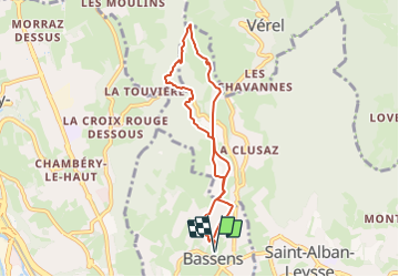
St Saturnin-Tilleret-18-09-23

papou73
User

Length
7.3 km

Max alt
563 m

Uphill gradient
305 m
Km-Effort
11.4 km

Min alt
317 m

Downhill gradient
306 m
Boucle
Yes
Creation date :
2023-09-18 07:29:17.044
Updated on :
2023-09-18 07:36:11.623
2h35
Difficulty : Medium

FREE GPS app for hiking
 SityTrail
IGN / Geographical institutes
SityTrail Plus
The world is yours!
About
Trail Walking of 7.3 km to be discovered at Auvergne-Rhône-Alpes, Savoy, Bassens. This trail is proposed by papou73.
Description
Au départ du parking Espace colombe (église de Bassens) circuit par la chapelle St Saturnin, le roc Mandrin, le Tilleret, la croix de bon secours, la Clusaz et retour Bassens.
Positioning
Country:
France
Region :
Auvergne-Rhône-Alpes
Department/Province :
Savoy
Municipality :
Bassens
Location:
Unknown
Start:(Dec)
Start:(UTM)
729438 ; 5051844 (31T) N.
Comments