


Espalion a Estaing

Nono55
User
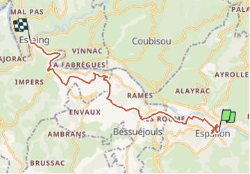

Length
15.5 km

Max alt
491 m

Uphill gradient
312 m
Km-Effort
19.7 km

Min alt
312 m

Downhill gradient
332 m
Boucle
No
Creation date :
2023-09-18 09:20:02.0
Updated on :
2023-09-18 14:47:40.815
3h47
Difficulty : Medium

FREE GPS app for hiking
 SityTrail
IGN / Geographical institutes
SityTrail Plus
The world is yours!
About
Trail Walking of 15.5 km to be discovered at Occitania, Aveyron, Espalion. This trail is proposed by Nono55.
Description
Deux villes exceptionnelles
Beau parcours avec différents point de vues
Positioning
Country:
France
Region :
Occitania
Department/Province :
Aveyron
Municipality :
Espalion
Location:
Unknown
Start:(Dec)
Start:(UTM)
481319 ; 4929808 (31T) N.
Comments