


Puy de Dôme - Croix St Robert

Gegetop
User
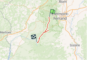

Length
48 km

Max alt
1727 m

Uphill gradient
1401 m
Km-Effort
67 km

Min alt
967 m

Downhill gradient
1449 m
Boucle
No
Creation date :
2023-09-11 08:00:50.858
Updated on :
2023-09-18 17:44:14.204
12h29
Difficulty : Difficult

FREE GPS app for hiking
 SityTrail
IGN / Geographical institutes
SityTrail Plus
The world is yours!
About
Trail Nordic walking of 48 km to be discovered at Auvergne-Rhône-Alpes, Puy-de-Dôme, Orcines. This trail is proposed by Gegetop.
Positioning
Country:
France
Region :
Auvergne-Rhône-Alpes
Department/Province :
Puy-de-Dôme
Municipality :
Orcines
Location:
Unknown
Start:(Dec)
Start:(UTM)
497074 ; 5068543 (31T) N.
Comments