Trail Walking Suzette - Suzette/prébayon - Photo
© OpenStreetMap contributors
Length
Length
17.1 km
Max alt
Max alt
572 m
Uphill gradient
Uphill gradient
519 m
Km-Effort
Km-Effort  
24 km
Min alt
Min alt
246 m
Downhill gradient
Downhill gradient
516 m
Boucle
Boucle
Yes
Creation date :
2015-03-02 00:00:00.0
Updated on :
2015-03-02 00:00:00.0

(0 Reviews)

Walking
Walking
5h26
Difficulty : Difficult

Scan this QR Code to open this trail in the SityTrail application

FREE GPS app for hiking

Logo SityTrail SityTrail

IGN / Geographical institutes

Download SityTrail from the App Store Download SityTrail from Google Play

Logo SityTrail SityTrail World

The world is yours!

Download SityTrail from the App Store Download SityTrail from Google Play Download SityTrail on Huawei AppGallery

About

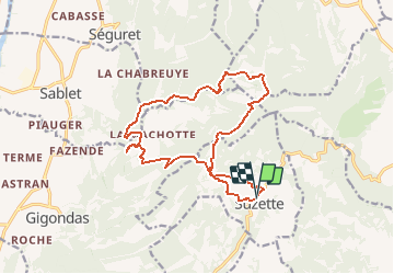
Trail Walking of 17.1 km to be discovered at Provence-Alpes-Côte d'Azur, Vaucluse, Suzette. This trail is proposed by alainbarrot.

Description

Superbe rando avec passages devant le domaine de la Verrière / Monastère de Prébayon / Chocolaterie de Lancieu puis un petit bonjour à Marco le Sanglier.

Elevation profile

Points of interest

Point of interest Gigondas - Chocolaterie de Lancieu - Photo
alainbarrot
Point of interest Gigondas - Marco le Sanglier - Photo
alainbarrot
Point of interest Séguret - Monastere de Prébayon - Photo
alainbarrot
Point of interest Crestet - Point 3les cypres - Photo
alainbarrot
Point of interest Crestet - Domaine la Verrière - Photo
alainbarrot

Positioning

Country:
France
Region :
Provence-Alpes-Côte d'Azur
Department/Province :
Vaucluse
Municipality :
Suzette
Location:
Unknown
Start:(UTM)
665316 ; 4892655 (31T) N.

Trails nearby

Trail Walking Séguret - 170917 EnCours - Photo
Walking
MarcheEtReve

Walking

Very easy
(1)
Séguret, Provence-Alpes-Côte d'Azur, Vaucluse, France
6.3 km | 9.8 km-effort
2h 8min
Yes
Trail Walking Lafare - Le tour du Grand Montmirail - Lafare - Photo
Walking
tracegps

Walking

Medium
(3)
Lafare, Provence-Alpes-Côte d'Azur, Vaucluse, France
9.1 km | 13.9 km-effort
2h 30min
Yes
Trail Walking Saint-Hippolyte-le-Graveyron - Le graveron petit circuit  - Photo
Walking
Vero7684

Walking

Easy
(1)
Saint-Hippolyte-le-Graveyron, Provence-Alpes-Côte d'Azur, Vaucluse, France
5.7 km | 8.8 km-effort
2h 5min
Yes
Trail Walking Lafare - Une approche des Dentelles de Montmirail - Photo
Walking
tracegps

Walking

Medium
(2)
Lafare, Provence-Alpes-Côte d'Azur, Vaucluse, France
6.6 km | 11.4 km-effort
3h 0min
Yes
Trail Walking Le Barroux - Lac du Barroux - Photo
Walking
alainbarrot

Walking

Very easy
(2)
Le Barroux, Provence-Alpes-Côte d'Azur, Vaucluse, France
5.8 km | 8 km-effort
1h 42min
Yes
Trail Running Le Barroux - Sortie Barroux - Photo
Running
ssi6159

Running

Very easy
(1)
Le Barroux, Provence-Alpes-Côte d'Azur, Vaucluse, France
12.9 km | 20 km-effort
1h 47min
Yes
Trail Walking Gigondas - les dentelles de Montmirail depuis Gigondas - Photo
Walking
alpha-pyxidis

Walking

Medium
(4)
Gigondas, Provence-Alpes-Côte d'Azur, Vaucluse, France
6.6 km | 11.3 km-effort
2h 26min
Yes
Trail Walking Sablet - 2024-01-12_13h24m19_sablet-prebayon-seguret-reco-validee - Photo
Walking
Maryma

Walking

Medium
(1)
Sablet, Provence-Alpes-Côte d'Azur, Vaucluse, France
19 km | 27 km-effort
6h 9min
Yes
Trail Walking Gigondas - Les dentelles de Montmirail depuis Gigondas - Photo
Walking
randochu

Walking

Medium
Gigondas, Provence-Alpes-Côte d'Azur, Vaucluse, France
17.9 km | 28 km-effort
6h 25min
No


Close
My subscriptions