


Castellane

Jean-Marie J
User

Length
14.2 km

Max alt
989 m

Uphill gradient
412 m
Km-Effort
19.5 km

Min alt
675 m

Downhill gradient
365 m
Boucle
No
Creation date :
2023-09-20 06:49:24.072
Updated on :
2023-09-20 12:39:20.522
3h50
Difficulty : Medium

FREE GPS app for hiking
 SityTrail
IGN / Geographical institutes
SityTrail Plus
The world is yours!
About
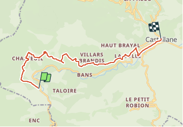
Trail Walking of 14.2 km to be discovered at Provence-Alpes-Côte d'Azur, Alpes-de-Haute-Provence, Castellane. This trail is proposed by Jean-Marie J.
Positioning
Country:
France
Region :
Provence-Alpes-Côte d'Azur
Department/Province :
Alpes-de-Haute-Provence
Municipality :
Castellane
Location:
Unknown
Start:(Dec)
Start:(UTM)
293389 ; 4855327 (32T) N.
Comments