


Bouvières St nazaire Ste Jalle

thonyc
User GUIDE
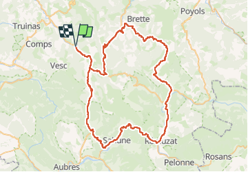

Length
92 km

Max alt
1032 m

Uphill gradient
1983 m
Km-Effort
119 km

Min alt
349 m

Downhill gradient
1984 m
Boucle
Yes
Creation date :
2023-09-20 14:22:30.764
Updated on :
2024-08-08 12:41:56.009
0m
Difficulty : Difficult

FREE GPS app for hiking
 SityTrail
IGN / Geographical institutes
SityTrail Plus
The world is yours!
About
Trail Cycle of 92 km to be discovered at Auvergne-Rhône-Alpes, Drôme, Crupies. This trail is proposed by thonyc.
Positioning
Country:
France
Region :
Auvergne-Rhône-Alpes
Department/Province :
Drôme
Municipality :
Crupies
Location:
Unknown
Start:(Dec)
Start:(UTM)
673748 ; 4935053 (31T) N.
Comments