


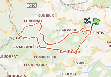
Vaugneray- Bois Barthélémy

Jean-Marc C
User

Length
9.4 km

Max alt
733 m

Uphill gradient
465 m
Km-Effort
15.6 km

Min alt
373 m

Downhill gradient
461 m
Boucle
Yes
Creation date :
2023-09-21 07:11:31.782
Updated on :
2023-09-21 10:18:18.879
3h06
Difficulty : Difficult

FREE GPS app for hiking
 SityTrail
IGN / Geographical institutes
SityTrail Plus
The world is yours!
About
Trail Walking of 9.4 km to be discovered at Auvergne-Rhône-Alpes, Rhône, Vaugneray. This trail is proposed by Jean-Marc C.
Positioning
Country:
France
Region :
Auvergne-Rhône-Alpes
Department/Province :
Rhône
Municipality :
Vaugneray
Location:
Vaugneray
Start:(Dec)
Start:(UTM)
628920 ; 5066409 (31T) N.
Comments