


Rochecolombe

raygautier
User
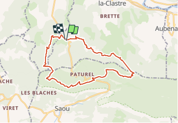

Length
17.4 km

Max alt
846 m

Uphill gradient
916 m
Km-Effort
30 km

Min alt
282 m

Downhill gradient
920 m
Boucle
Yes
Creation date :
2023-09-21 06:18:03.0
Updated on :
2023-09-21 17:01:27.417
6h20
Difficulty : Very difficult

FREE GPS app for hiking
 SityTrail
IGN / Geographical institutes
SityTrail Plus
The world is yours!
About
Trail Walking of 17.4 km to be discovered at Auvergne-Rhône-Alpes, Drôme, Piégros-la-Clastre. This trail is proposed by raygautier.
Positioning
Country:
France
Region :
Auvergne-Rhône-Alpes
Department/Province :
Drôme
Municipality :
Piégros-la-Clastre
Location:
Unknown
Start:(Dec)
Start:(UTM)
663724 ; 4949447 (31T) N.
Comments