


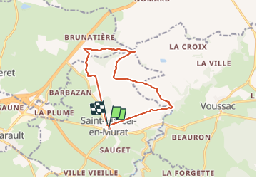
Rando St Marcel

Guy Laurent
User

Length
12.9 km

Max alt
490 m

Uphill gradient
181 m
Km-Effort
15.3 km

Min alt
387 m

Downhill gradient
180 m
Boucle
Yes
Creation date :
2023-09-24 06:45:22.447
Updated on :
2023-09-24 11:29:32.169
3h55
Difficulty : Difficult

FREE GPS app for hiking
 SityTrail
IGN / Geographical institutes
SityTrail Plus
The world is yours!
About
Trail Walking of 12.9 km to be discovered at Auvergne-Rhône-Alpes, Allier, Saint-Marcel-en-Murat. This trail is proposed by Guy Laurent.
Positioning
Country:
France
Region :
Auvergne-Rhône-Alpes
Department/Province :
Allier
Municipality :
Saint-Marcel-en-Murat
Location:
Unknown
Start:(Dec)
Start:(UTM)
500680 ; 5129675 (31T) N.
Comments