


St sauveur Bpjeps

cps46
User
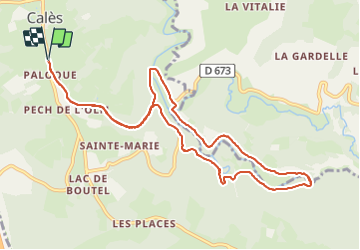

Length
11.4 km

Max alt
266 m

Uphill gradient
282 m
Km-Effort
15.1 km

Min alt
107 m

Downhill gradient
282 m
Boucle
Yes
Creation date :
2023-09-25 11:24:56.0
Updated on :
2023-09-25 14:34:51.843
3h09
Difficulty : Difficult

FREE GPS app for hiking
 SityTrail
IGN / Geographical institutes
SityTrail Plus
The world is yours!
About
Trail Walking of 11.4 km to be discovered at Occitania, Lot, Calès. This trail is proposed by cps46.
Positioning
Country:
France
Region :
Occitania
Department/Province :
Lot
Municipality :
Calès
Location:
Unknown
Start:(Dec)
Start:(UTM)
384449 ; 4962357 (31T) N.
Comments