


Bâtais Cahors gare

Nono55
User

Length
38 km

Max alt
378 m

Uphill gradient
510 m
Km-Effort
45 km

Min alt
112 m

Downhill gradient
701 m
Boucle
No
Creation date :
2023-09-25 05:35:41.0
Updated on :
2023-09-25 15:06:41.45
8h16
Difficulty : Medium

FREE GPS app for hiking
 SityTrail
IGN / Geographical institutes
SityTrail Plus
The world is yours!
About
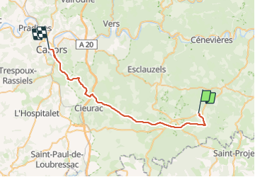
Trail Walking of 38 km to be discovered at Occitania, Lot, Varaire. This trail is proposed by Nono55.
Description
Chemin en sous bois super
Journée très chaude
Descente sur Cahors très difficile après une journée pareil
Positioning
Country:
France
Region :
Occitania
Department/Province :
Lot
Municipality :
Varaire
Location:
Unknown
Start:(Dec)
Start:(UTM)
398150 ; 4912728 (31T) N.
Comments