


Cimetière d’Etiolles

gentileadriano
User
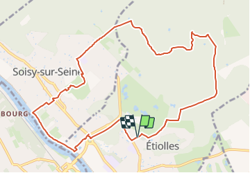

Length
11.2 km

Max alt
98 m

Uphill gradient
121 m
Km-Effort
12.8 km

Min alt
32 m

Downhill gradient
125 m
Boucle
Yes
Creation date :
2023-09-26 12:25:41.0
Updated on :
2023-09-26 12:25:49.04
2h55
Difficulty : Easy

FREE GPS app for hiking
 SityTrail
IGN / Geographical institutes
SityTrail Plus
The world is yours!
About
Trail Walking of 11.2 km to be discovered at Ile-de-France, Essonne, Étiolles. This trail is proposed by gentileadriano.
Positioning
Country:
France
Region :
Ile-de-France
Department/Province :
Essonne
Municipality :
Étiolles
Location:
Unknown
Start:(Dec)
Start:(UTM)
461070 ; 5387512 (31U) N.
Comments