


saint Nectaire les grottes de Chateauneuf Sapchat 19km

jeanic63
User
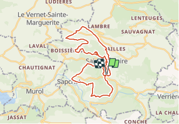

Length
19.4 km

Max alt
982 m

Uphill gradient
667 m
Km-Effort
28 km

Min alt
682 m

Downhill gradient
668 m
Boucle
Yes
Creation date :
2023-09-26 16:16:19.313
Updated on :
2023-09-26 16:41:26.343
6h25
Difficulty : Medium

FREE GPS app for hiking
 SityTrail
IGN / Geographical institutes
SityTrail Plus
The world is yours!
About
Trail On foot of 19.4 km to be discovered at Auvergne-Rhône-Alpes, Puy-de-Dôme, Saint-Nectaire. This trail is proposed by jeanic63.
Description
départ saint Nectaire vers le parking du casino
Positioning
Country:
France
Region :
Auvergne-Rhône-Alpes
Department/Province :
Puy-de-Dôme
Municipality :
Saint-Nectaire
Location:
Unknown
Start:(Dec)
Start:(UTM)
499429 ; 5047603 (31T) N.
Comments