


Minorca J6

CABERMAT
User
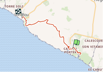

Length
13.9 km

Max alt
81 m

Uphill gradient
281 m
Km-Effort
17.7 km

Min alt
0 m

Downhill gradient
315 m
Boucle
No
Creation date :
2023-09-27 06:35:20.432
Updated on :
2023-09-27 12:38:53.503
6h02
Difficulty : Difficult

FREE GPS app for hiking
 SityTrail
IGN / Geographical institutes
SityTrail Plus
The world is yours!
About
Trail Walking of 13.9 km to be discovered at Balearic Islands, Unknown, Alaior. This trail is proposed by CABERMAT.
Positioning
Country:
Spain
Region :
Balearic Islands
Department/Province :
Unknown
Municipality :
Alaior
Location:
Unknown
Start:(Dec)
Start:(UTM)
597334 ; 4413969 (31S) N.
Comments