


adeps15km citadelle telepherique

mdieu
User
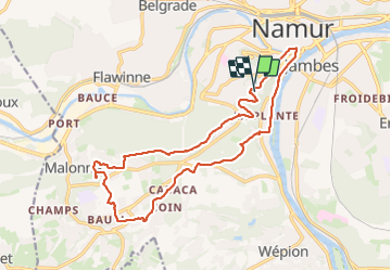

Length
16.7 km

Max alt
230 m

Uphill gradient
370 m
Km-Effort
22 km

Min alt
77 m

Downhill gradient
375 m
Boucle
Yes
Creation date :
2023-09-27 10:31:05.616
Updated on :
2023-09-27 14:48:44.354
4h17
Difficulty : Medium

FREE GPS app for hiking
 SityTrail
IGN / Geographical institutes
SityTrail Plus
The world is yours!
About
Trail Walking of 16.7 km to be discovered at Wallonia, Namur, Namur. This trail is proposed by mdieu.
Positioning
Country:
Belgium
Region :
Wallonia
Department/Province :
Namur
Municipality :
Namur
Location:
Namur
Start:(Dec)
Start:(UTM)
631625 ; 5590742 (31U) N.
Comments