


Pont

raygautier
User
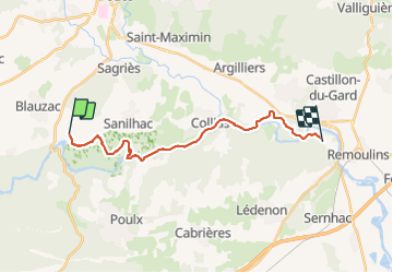

Length
20 km

Max alt
179 m

Uphill gradient
339 m
Km-Effort
25 km

Min alt
19 m

Downhill gradient
357 m
Boucle
No
Creation date :
2023-09-30 07:10:02.0
Updated on :
2023-09-30 15:18:09.043

FREE GPS app for hiking
 SityTrail
IGN / Geographical institutes
SityTrail Plus
The world is yours!
About
Trail of 20 km to be discovered at Occitania, Gard, Sanilhac-Sagriès. This trail is proposed by raygautier.
Positioning
Country:
France
Region :
Occitania
Department/Province :
Gard
Municipality :
Sanilhac-Sagriès
Location:
Unknown
Start:(Dec)
Start:(UTM)
611423 ; 4867198 (31T) N.
Comments