


pré Barbier boucle

Titinechris
User
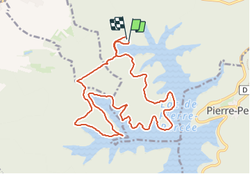

Length
10.8 km

Max alt
440 m

Uphill gradient
213 m
Km-Effort
13.6 km

Min alt
385 m

Downhill gradient
199 m
Boucle
Yes
Creation date :
2023-10-01 08:14:31.484
Updated on :
2023-10-01 09:51:00.144
1h36
Difficulty : Very easy

FREE GPS app for hiking
 SityTrail
IGN / Geographical institutes
SityTrail Plus
The world is yours!
About
Trail Running of 10.8 km to be discovered at Grand Est, Meurthe-et-Moselle, Badonviller. This trail is proposed by Titinechris.
Positioning
Country:
France
Region :
Grand Est
Department/Province :
Meurthe-et-Moselle
Municipality :
Badonviller
Location:
Unknown
Start:(Dec)
Start:(UTM)
345233 ; 5371742 (32U) N.
Comments