


col de la Moutiere

franquen
User

Length
18.1 km

Max alt
2446 m

Uphill gradient
1308 m
Km-Effort
31 km

Min alt
1169 m

Downhill gradient
54 m
Boucle
No
Creation date :
2023-09-12 08:29:20.279
Updated on :
2023-10-02 13:55:47.999
1h39
Difficulty : Difficult

FREE GPS app for hiking
 SityTrail
IGN / Geographical institutes
SityTrail Plus
The world is yours!
About
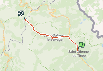
Trail Mountain bike of 18.1 km to be discovered at Provence-Alpes-Côte d'Azur, Maritime Alps, Saint-Étienne-de-Tinée. This trail is proposed by franquen.
Positioning
Country:
France
Region :
Provence-Alpes-Côte d'Azur
Department/Province :
Maritime Alps
Municipality :
Saint-Étienne-de-Tinée
Location:
Unknown
Start:(Dec)
Start:(UTM)
334127 ; 4902923 (32T) N.
Comments