


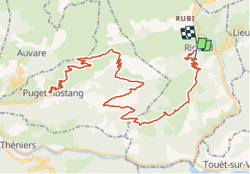
Rigaud Puget Rostang par le col de la Mairola

franquen
User

Length
44 km

Max alt
1475 m

Uphill gradient
1559 m
Km-Effort
65 km

Min alt
646 m

Downhill gradient
1745 m
Boucle
No
Creation date :
2023-10-02 09:15:43.149
Updated on :
2023-10-02 16:18:38.224
4h39
Difficulty : Easy

FREE GPS app for hiking
 SityTrail
IGN / Geographical institutes
SityTrail Plus
The world is yours!
About
Trail Mountain bike of 44 km to be discovered at Provence-Alpes-Côte d'Azur, Maritime Alps, Rigaud. This trail is proposed by franquen.
Description
rando assez longue mais pas difficile de beaux paysages notamment la descente sur Puget Rostang. Chemin très caillouteux pour atteindre le col.
Positioning
Country:
France
Region :
Provence-Alpes-Côte d'Azur
Department/Province :
Maritime Alps
Municipality :
Rigaud
Location:
Unknown
Start:(Dec)
Start:(UTM)
338756 ; 4872238 (32T) N.
Comments