


20231003-Bonnemare

doudet
User
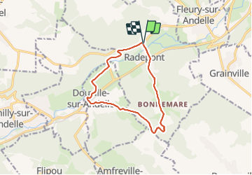

Length
11 km

Max alt
156 m

Uphill gradient
278 m
Km-Effort
14.7 km

Min alt
15 m

Downhill gradient
278 m
Boucle
Yes
Creation date :
2023-10-03 11:49:27.75
Updated on :
2023-10-04 06:22:15.898
3h19
Difficulty : Difficult

FREE GPS app for hiking
 SityTrail
IGN / Geographical institutes
SityTrail Plus
The world is yours!
About
Trail Walking of 11 km to be discovered at Normandy, Eure, Radepont. This trail is proposed by doudet.
Description
Boucle Z-R au départ de la salle des fêtes de Radepont
Positioning
Country:
France
Region :
Normandy
Department/Province :
Eure
Municipality :
Radepont
Location:
Unknown
Start:(Dec)
Start:(UTM)
378368 ; 5468331 (31U) N.
Comments