


10 km gite les bruns valdivienne

totof17
User
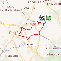

Length
10.1 km

Max alt
137 m

Uphill gradient
96 m
Km-Effort
11.3 km

Min alt
96 m

Downhill gradient
96 m
Boucle
Yes
Creation date :
2015-02-03 00:00:00.0
Updated on :
2015-02-03 00:00:00.0
1h07
Difficulty : Easy

FREE GPS app for hiking
 SityTrail
IGN / Geographical institutes
SityTrail Plus
The world is yours!
About
Trail Running of 10.1 km to be discovered at New Aquitaine, Vienne, Valdivienne. This trail is proposed by totof17.
Positioning
Country:
France
Region :
New Aquitaine
Department/Province :
Vienne
Municipality :
Valdivienne
Location:
Unknown
Start:(Dec)
Start:(UTM)
313371 ; 5151056 (31T) N.
Comments