


st jacques Schoenenbourg

MAD-CVW
User

Length
8.2 km

Max alt
216 m

Uphill gradient
113 m
Km-Effort
9.8 km

Min alt
157 m

Downhill gradient
144 m
Boucle
No
Creation date :
2023-10-01 07:05:55.807
Updated on :
2023-10-08 07:16:54.954
167h35
Difficulty : Medium

FREE GPS app for hiking
 SityTrail
IGN / Geographical institutes
SityTrail Plus
The world is yours!
About
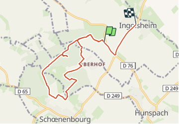
Trail Walking of 8.2 km to be discovered at Grand Est, Bas-Rhin, Ingolsheim. This trail is proposed by MAD-CVW.
Positioning
Country:
France
Region :
Grand Est
Department/Province :
Bas-Rhin
Municipality :
Ingolsheim
Location:
Unknown
Start:(Dec)
Start:(UTM)
421341 ; 5424609 (32U) N.
Comments